 Every Lake
Among the Minnesota lakes we map, the deepest is Leech Lake, at 156 feet. Behind it come Burntside Lake at 126 feet, and Cass Lake and Otter Tail Lake, both at 120. That is a list of the lakes on our shelves, not a ruling on the whole state. Minnesota has far more lakes than any one catalog holds, so if yours is missing, search for it.
The second question people ask is how deep Lake Minnetonka is. Its maximum depth is 113 feet. Most of the lake is much shallower than that, and the deep water is a small part of a big, branching shoreline. The rest of this guide covers where those numbers come from and why they matter if you fish, skate or look at the lake from a porch.
Why "10,000 lakes" says little about depth
The nickname counts lakes. It says nothing about how far down any of them go. Minnesota's lakes were mostly left by retreating glaciers: blocks of buried ice melted into kettles, and moving ice scoured long troughs into the rock and gravel. The shape of a basin comes from what the ice did in that exact spot.
The result is that a big lake is not necessarily a deep one. Some of the largest water in the state is a wide, shallow pan. A small lake with a lot of shoreline can hide a hole that drops off a steep slope close to shore. Surface area tells you how much room there is. Maximum depth tells you what the bottom looks like.
The deep end of the list
These are the lakes we map with a published maximum depth, ranked by that number. Depth figures come from Wikipedia's entry for each lake.
| Lake | Max depth | Area |
|---|---|---|
| Leech Lake | 156 ft | 163.1 sq mi |
| Burntside Lake | 126 ft | 11.9 sq mi |
| Cass Lake | 120 ft | 30.8 sq mi |
| Otter Tail Lake | 120 ft | 21.8 sq mi |
| Lake Minnetonka | 113 ft | 12.6 sq mi |
| Detroit Lake | 89 ft | 4.8 sq mi |
| Big Sandy Lake | 84 ft | 12.7 sq mi |
| White Bear Lake | 83 ft | 3.7 sq mi |
| Gull Lake | 80 ft | 18.0 sq mi |
| Brule Lake | 78 ft | 6.7 sq mi |
| Lake Vermilion | 76 ft | 67.6 sq mi |
Read the table and look at the area column. Leech is both the deepest and the largest on the list, which is not what you would predict. Burntside holds 126 feet in under twelve square miles. Lake Vermilion covers more than five times that area and tops out at 76 feet.
Leech Lake: the deep water in the north
Leech Lake is Minnesota's third-largest lake, and it sits in the middle of the Leech Lake Band's Ojibwe homeland. At 156 feet it is the deepest water in our Minnesota collection. A map of it shows a lake with many personalities: sheltered bays, long points, shallow flats and a deep basin that most visitors never see from the surface.
On a layered map, a lake like this reads well. The deepest contour is a small island of wood in the middle, and a wide ring of shallower layers steps out toward the shore.
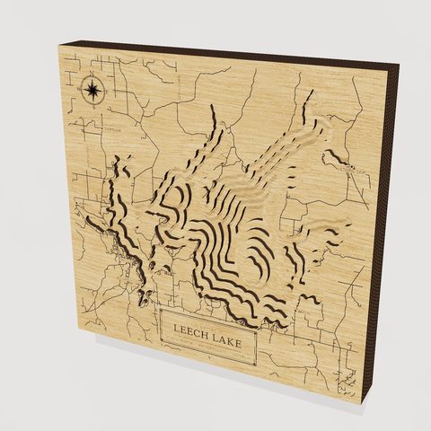 Leech LakeMN · 3D wood depth map · from $149
Close by are two other lakes on the 120-foot line. Cass Lake has Star Island in the middle, and that island holds a lake of its own. Otter Tail Lake is the largest lake in a county named for the same river system.
How deep is Lake Minnetonka, really?
The 113 feet is the deepest spot. Minnetonka is better understood as a district of connected bays than as one bowl. Lake Minnetonka has sixteen named bays and 125 miles of shoreline, and each bay has its own character. Some are shallow and weedy. Others fall away to open, deep water. A boater crossing from one bay to the next can go from a few feet under the keel to a good deal more.
That variety is why Minnetonka makes a good depth map. The deep basin and the maze of shallow bays can be told apart by the layers of wood, and the shape of the shore is very different from that of a round, symmetrical lake.
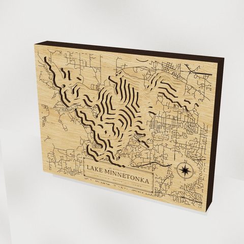 Lake MinnetonkaMN · 3D wood depth map · from $149
Small lakes that go deep
Burntside Lake, near Ely, is the clearest example. It has more than 100 islands and 71 miles of shoreline packed into about 12 square miles, and its 126-foot maximum depth is the second-deepest on our list. Water like this is cold and clear, and the bottom drops off quickly from the rocky shore. Burntside Lake shows well in layers because the contours bunch tightly around the islands.
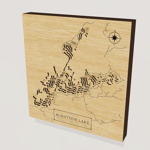 Burntside LakeMN · 3D wood depth map · from $149
White Bear Lake is another. It has been a resort lake since the 1880s on the northeast edge of the Twin Cities, and it reaches 83 feet in only 3.7 square miles. Detroit Lake, in Becker County, reaches 89 feet and is split into a big and a little basin by a gravel bar. And Brule Lake, with no motors, no cabins and 39 miles of undeveloped shoreline, goes to 78 feet.
Big and shallow: the other half of the story
Lake Mille Lacs covers 200.9 square miles and has a maximum depth of 42 feet. It is one of the state's biggest lakes and its most famous walleye water, and it is a broad, shallow basin where wind can stir the whole lake. Lake Winnibigoshish was dammed in 1884 to steady Mississippi River log drives, and it reaches 70 feet. Smaller lakes like Chisago Lake (32 feet) and Medicine Lake (49 feet) round out the shallow end of the lakes we map.
Shallow does not mean lesser. Warm, shallow water grows weeds and insects, and that feeds fish. Many of the best-known walleye lakes in the state are exactly this kind of lake.
What depth changes on the water
- Fishing. Deep lakes stratify in summer: a warm layer sits over cold water, and cold-water species such as lake trout and cisco live below it. Shallow lakes mix more often and tend to favor walleye, perch and panfish.
- Color. Deeper, clearer lakes look darker blue from above. Shallow, nutrient-rich lakes look green or brown, and wind can cloud them.
- Ice. Shallow lakes freeze first and thaw first. Deep lakes hold heat longer, close up later in the fall and open later in the spring.
- Shoreline. A steep drop-off close to the dock means swimmable water early. A long, gentle shelf means wading and weeds.
Choosing a size and wording the line
A deep, large lake like Leech Lake gains from the larger sizes, where there is room for each contour to show. The 12-inch map is $149, the 17-inch is $249, the 24-inch is $399 and the 30-inch is $599. For a compact lake with many islands, the 17-inch works well, because the detail is in the shoreline more than in the depth.
At checkout you can add a family or cabin name, a short message, and a star on any spot on the shore. Keep the message to what you would say aloud on the dock: a year, a first name, the name of the cabin. A star works best on a place with a story, like the point where the first dock went in or the bay where someone proposed.
About these maps
Every Lake maps are made to order in Waterford, Pennsylvania. Each layer of birch is cut to one depth contour, stacked, and finished with shore roads and towns engraved on top. They are made for the wall, not for navigation. Shipping is free in the lower 48 and most maps leave in about seven to ten days. If your lake is not among the ones above, you can search for it or commission it, and you can browse more on the lakes page.


